
You are using an out of date browser. It may not display this or other websites correctly.
You should upgrade or use an alternative browser.
You should upgrade or use an alternative browser.
Container Port Ideas & Images
- Thread starter beiland
- Start date
So yesterday after several non-railroad projects I looked back at the container port ideas,.... and decided that I needed to modify one of those ends where I would be having trucks entering and leaving as they brought containers from the 'backyard' to the center pad roadway for loading/unloading onto the container cars.
Originally I had thought I would put that one crossing up where it would end up crossing over a turnout of the back track.....no, no, I had to move that down, thus shift the pads for the container cranes over about 5 inches to the right.


The other end will also have an image of a truck hauling a container out of the 'backyard' as though it passes down a 'street' boarded by stacked containers,..
(perhaps I may slice one of those truck/container chassis in half and place it in such manner?)

Eventually I will need to add fillers to make it look like just the railheads are exposed from these concrete pads.
Originally I had thought I would put that one crossing up where it would end up crossing over a turnout of the back track.....no, no, I had to move that down, thus shift the pads for the container cranes over about 5 inches to the right.
The other end will also have an image of a truck hauling a container out of the 'backyard' as though it passes down a 'street' boarded by stacked containers,..
(perhaps I may slice one of those truck/container chassis in half and place it in such manner?)
Eventually I will need to add fillers to make it look like just the railheads are exposed from these concrete pads.
ctclibby
Well-Known Member
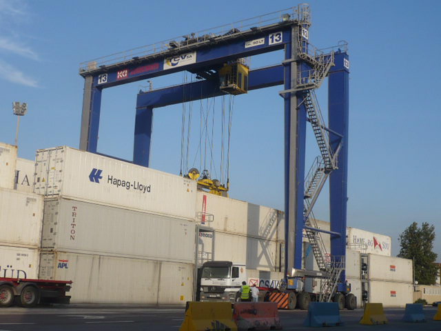
If you have trucks coming in for said containers -
Taken at Port Elizabeth NJ a few years back.

We usually go to Jax Port every once in awhile. Next time I will try and get a series of pix from the truck perspective.
I have planned to visit the BNSF Memphis container facility and will get pix there also.
Taken at Port Elizabeth NJ a few years back.
We usually go to Jax Port every once in awhile. Next time I will try and get a series of pix from the truck perspective.
I have planned to visit the BNSF Memphis container facility and will get pix there also.
TrucTrain55
Well-Known Member
Hauled many Containers going to that port and still do every week. I always wonder what it looked like thanks for sharingIf you have trucks coming in for said containers -
Taken at Port Elizabeth NJ a few years back.
View attachment 145929
We usually go to Jax Port every once in awhile. Next time I will try and get a series of pix from the truck perspective.
I have planned to visit the BNSF Memphis container facility and will get pix there also.
Snowman
Well-Known Member
Interesting that you picked this image, as I had just linked to the page and was going to cut and paste it for your perusal (Sirfoldalot nailed it right off with that multi-image link). I would definitely use a photo, btw, and not try to paint it. Fade the photo with oversprays or overwashes if desired (for distance, and to make details somewhat indistinct or not, as required), but don't paint one unless you are talented at architectural/industrial drawing.One of the very first images I saw there on that link was the 'viewing angle' I actually need
View attachment 39584
https://upload.wikimedia.org/wikipe...odal_container_in_Port_of_Chittagong_(17).jpg
It would make a fine backdrop, oriented looking from container yard looking out toward the water, and because it's shadowed from the camera's viewpoint, it's "generic" enough in terms of lighting that you could print it up or have it blown up at a print shop, and then reverse it too--the original and its mirror image. The image above looks at the left side of both container cranes, while its mirror image looks at the right side.... Match them end to end at the far left edge of [this] image, and the far right edge of its mirror opposite, and you have a well framed backdrop which has a "forced perspective" built right into it. The four big cranes being your framing....
IMO, a container yard-to-truck loader (from the mid-deep storage yard to closest foreground truck loading) could really give it some real zap, and some real depth too, making it look like a large, deep yard, viewed from the front, not just a couple or three yard tracks. If you can work one in at all, I would do it.
As far as hiding the "not-seen-at-the-oceanside" coal train through track in the back, why not build up the flat, vertical side of a container ship itself, and run the track just behind it? A sort of "low height backdrop," with MAERSK or EVERGREEN writ large behind or above the grounded containers? Curve the bow and stern back away (for depth), disguise the bow and stern "tunnel ends" with stacks of containers, and stack a few containers (or container flats) along the top of the hull, enough to give it a near-foreground feel. With that backdrop. Zing! Interest from the front all the way to the back, and in multiple layers too.
[A container yard is a natural for layering images, btw. Much easier than almost any other layered scene IMO]
Curious to see what you come up with.
Last edited:
Snowman
Well-Known Member
There are three ports in So Cal large enough for container yards: LA, Long Beach and (possibly) San Diego. Of the three, San Diego is by far the best choice for combining naval/(possible) commercial shipping/container traffic with a downtown Santa Fe station as it pretty much does just that IRL.
Looking out to the west, the far distant horizon at both LA and Long Beach is what you see, regardless of viewing height. Which begs the question: What is the viewing height for a typical yard viewer/operator here? Standing? Sitting? Closer to ground level the better, IMO, so you avoid looking "down" at a distant horizon as much as possible.
San Diego is quite different: Looking west out and over the top of said yard or station, you view the eastern side of Point Loma which looms ABOVE what would otherwise be the same ocean horizon viewed at many other ports...and even though North Island NAS fills up the middle of the harbor, the wall of Point Loma still seems close (to my eye, anyway).
Further south, along the Silver Strand, the far horizon opens up to a the normal flat line, which is fine...but the SD-SF-now Amtrak depot is downtown, and inside the arm of Point Loma--perfect, IMO.
------------------------------
FWIW, and as to why I wax so enthusiastic about San Diego: It's the western terminus for my own railroad "scheme," right down to the palm trees.
A natural for me, as my paternal grandfather was chief dispatcher there (for the Santa Fe), right through the end of WWII--he died in 1947.
As it happens, mom's two oldest sisters ran the Railway Express Agency station atop the small "pass"--I might almost call it "Miramar Pass"-- where the Coastline heads north out of the city. There was then and still is now a wye atop the pass, and I THINK (but am still not sure) that small REA agency/station sat inside the wye itself. A busy place during the war, as the Marine Corps staging base at Camp Elliott* was the terminus for the leg that ran east off that wye. AFAIK, almost every Marine who fought in the Pacific, from Guadalcanal, right through Iwo Jima and beyond originally staged at Camp Elliot before shipping out.
[*Some of the old foundations at Elliott might be here:
 www.google.ca
As far as the wye, you can see it on Google earth NNE of the city. It seems to be home to a "dead boat yard" today. Pretty sure I can see the remains of both the SS Minnow and PT 73 just laying about....
 www.google.ca
Love your work, beiland.
Looking out to the west, the far distant horizon at both LA and Long Beach is what you see, regardless of viewing height. Which begs the question: What is the viewing height for a typical yard viewer/operator here? Standing? Sitting? Closer to ground level the better, IMO, so you avoid looking "down" at a distant horizon as much as possible.
San Diego is quite different: Looking west out and over the top of said yard or station, you view the eastern side of Point Loma which looms ABOVE what would otherwise be the same ocean horizon viewed at many other ports...and even though North Island NAS fills up the middle of the harbor, the wall of Point Loma still seems close (to my eye, anyway).
Further south, along the Silver Strand, the far horizon opens up to a the normal flat line, which is fine...but the SD-SF-now Amtrak depot is downtown, and inside the arm of Point Loma--perfect, IMO.
------------------------------
FWIW, and as to why I wax so enthusiastic about San Diego: It's the western terminus for my own railroad "scheme," right down to the palm trees.
A natural for me, as my paternal grandfather was chief dispatcher there (for the Santa Fe), right through the end of WWII--he died in 1947.
As it happens, mom's two oldest sisters ran the Railway Express Agency station atop the small "pass"--I might almost call it "Miramar Pass"-- where the Coastline heads north out of the city. There was then and still is now a wye atop the pass, and I THINK (but am still not sure) that small REA agency/station sat inside the wye itself. A busy place during the war, as the Marine Corps staging base at Camp Elliott* was the terminus for the leg that ran east off that wye. AFAIK, almost every Marine who fought in the Pacific, from Guadalcanal, right through Iwo Jima and beyond originally staged at Camp Elliot before shipping out.
[*Some of the old foundations at Elliott might be here:
Google Maps
Find local businesses, view maps and get driving directions in Google Maps.
As far as the wye, you can see it on Google earth NNE of the city. It seems to be home to a "dead boat yard" today. Pretty sure I can see the remains of both the SS Minnow and PT 73 just laying about....
Google Maps
Find local businesses, view maps and get driving directions in Google Maps.
Love your work, beiland.
Last edited:
Snowman
Well-Known Member
Google Maps
Find local businesses, view maps and get driving directions in Google Maps.
Google street view looking east at the San Diego Santa Fe depot^^^
Google Maps
Find local businesses, view maps and get driving directions in Google Maps.
Looking west across the bay, Point Loma farthest (with North Island NAS and the Coronado Hotel to the left). I would enlarge it quite a lot, myself--increase its height.
IMO too, the Coronado Bridge, which soars upward, so you look at it from underneath, if you are close enough, would also be good for left end panoramic view framing.
If you have trucks coming in for said containers -
Taken at Port Elizabeth NJ a few years back.
View attachment 145929
We usually go to Jax Port every once in awhile. Next time I will try and get a series of pix from the truck perspective.
I have planned to visit the BNSF Memphis container facility and will get pix there also.
I believe this type of straddle crane (Mi-jack?) is not the type utilized to load train cars,..but rather one designed to snatch containers off of high stacks and load them onto either trucks leaving the port facility, or onto 'transfer chassis' to be taken over to the train loading Mi-jacks.
In my scene I am NOT trying to include those container trucks being loaded for long haul shipping out of the port. My port operations are strictly the transfer chassis bringing containers out to the rail car loading Mi-jacks, ....or the reverse containers being off loaded from the rail cars and taken back into the port area storage stacks.


One item I wish was produced (and at a reasonable price) is an Mi-jack crane of a taller nature,..
.something like this...

or this
Last edited:
ctclibby
Well-Known Member
Those straddle cranes can't get up very high. Would not work at all @ JaxPort as I have seen stacks 6 or 7 containers high. They use another type which is more or less a fork type truck with big grabbers. Grabbers pick by the top of the container and change in length depending on the container. Tires for the things almost come up to the bottom of the tractor window - in other words - BIG. When ( if ) we get back to Jax, will get some pix as I have stated before.
Interesting that you picked this image, as I had just linked to the page and was going to cut and paste it for your perusal (Sirfoldalot nailed it right off with that multi-image link). I would definitely use a photo, btw, and not try to paint it. Fade the photo with oversprays or overwashes if desired (for distance, and to make details somewhat indistinct or not, as required), but don't paint one unless you are talented at architectural/industrial drawing.
It would make a fine backdrop, oriented looking from container yard looking out toward the water, and because it's shadowed from the camera's viewpoint, it's "generic" enough in terms of lighting that you could print it up or have it blown up at a print shop, and then reverse it too--the original and its mirror image. The image above looks at the left side of both container cranes, while its mirror image looks at the right side.... Match them end to end at the far left edge of [this] image, and the far right edge of its mirror opposite, and you have a well framed backdrop which has a "forced perspective" built right into it. The four big cranes being your framing....
IMO, a container yard-to-truck loader (from the mid-deep storage yard to closest foreground truck loading) could really give it some real zap, and some real depth too, making it look like a large, deep yard, viewed from the front, not just a couple or three yard tracks. If you can work one in at all, I would do it.
As far as hiding the "not-seen-at-the-oceanside" coal train through track in the back, why not build up the flat, vertical side of a container ship itself, and run the track just behind it? A sort of "low height backdrop," with MAERSK or EVERGREEN writ large behind or above the grounded containers? Curve the bow and stern back away (for depth), disguise the bow and stern "tunnel ends" with stacks of containers, and stack a few containers (or container flats) along the top of the hull, enough to give it a near-foreground feel. With that backdrop. Zing! Interest from the front all the way to the back, and in multiple layers too.
[A container yard is a natural for layering images, btw. Much easier than almost any other layered scene IMO]
Curious to see what you come up with.
Most interesting, your observations. I think I may have to reread it several times to understand your ideas.
I think at one time I considered including the container ship's side, but then I thought I could not make the scene very deep if the container ship were large enough to hide that hidden track?
Would you be able to illustrate (roughly) what you are speaking of by using a reverse image and mirror of it??
Just yesterday I thought about making some sort of collage/photomontage of photo images to create that big container yard behind the stacked containers i had up front?? Would this collage be similar to what you suggested?....
[A container yard is a natural for layering images, btw. Much easier than almost any other layered scene IMO]
Last edited:
This west cost container yard is on the upper deck of my layout,...58" above the floor,..so eye level for me at 6'4".Looking out to the west, the far distant horizon at both LA and Long Beach is what you see, regardless of viewing height. Which begs the question: What is the viewing height for a typical yard viewer/operator here? Standing? Sitting? Closer to ground level the better, IMO, so you avoid looking "down" at a distant horizon as much as possible.
Love your work, beiland.
Thanks for the compliment. I'm trying my best, but it doesn't compare to what some modelers do.
ctclibby
Well-Known Member
Beiland: You might consider only using part of a ship. Just enough for our brains to put the rest together and tell us 'it is a ship'. Looks like there is not much depth where you want it, although if it does hide that rear track, start there and work forward. You probably do not need to use the actual size of the ship as you can reduce it in scale. Brain will still know it is a ship.
As to the background photo's of the containers - I would think that you would really need a 'forced perspective' as there are a lot of 90 degree corners, straight lines and such. IE, if you look at it somewhat from the side, foreground containers would not match the background; shadows would also be different.
It is gonna be fun to see what you come up with!
Regrettably I am going to have to ponder this background image for awhile as I need to get the rest of my upper deck wired for DCC, and build that bridge for these upper tracks to cross my entrance-way (third layer to my swing down structure,..link)
...but keep the ideas and photos coming.
...but keep the ideas and photos coming.
ctclibby
Well-Known Member
Ya, never ending battle. The more you get done, that happier you will be.
Just another thought - The background may become a non-issue - what is on the other side of that ship. Except for Port Hueneme ( Oxnard CA ) there is pretty much nothing but blue sky and ocean that I have seen. Some are in a bay or reach which has distance to other objects with water between which would be way in the background. Good thing we can selectively compress stuff keeping the busy parts and junk the rest.
Just another thought - The background may become a non-issue - what is on the other side of that ship. Except for Port Hueneme ( Oxnard CA ) there is pretty much nothing but blue sky and ocean that I have seen. Some are in a bay or reach which has distance to other objects with water between which would be way in the background. Good thing we can selectively compress stuff keeping the busy parts and junk the rest.
boatwrench
Well-Known Member
Just wondering what Railbox cars are used for at a container terminal?
ctclibby
Well-Known Member
My guess is that they do cross dock transloading. Out of a container, into Railbox. Those look to be hi-cube and not refers. Question to ask if/when I get back there.Just wondering what Railbox cars are used for at a container terminal?
Last edited:
Just a start on some experimentation. I went to my locale Staples and had them blow that original image up into 2 new sizes,..20" wide, and 24" wide. I stuck with just black & white images to experiment with,


One question that arose almost immediately is how do I get that 'white space' around the crane images to be the same blue sky color I have used? Is there a way that can be done with photo-shopping? ,......or do I need to do some sort of cut & paste?
Or should I consider some sort of removal of the cranes themselves, the add them back in after sky color is added?
Hope some photo-shopping folks can help me with suggestions.
Last edited:
Then a second question, what if I added a 'reversed image' to the right of the first one,..something like this. Two 29" wide images would add up to the total of 58" ,...the length between my to truck entrances at either end.

Oops. I screwed up, those images where suppose to be the other way around,..for the forced perspective.
EDITED: This is the corrected image,..

Now how do I correct those containers names that are reading in reverse?
Oops. I screwed up, those images where suppose to be the other way around,..for the forced perspective.
EDITED: This is the corrected image,..
Now how do I correct those containers names that are reading in reverse?
Last edited:
ctclibby
Well-Known Member
Good pix. Photoshop, Gimp or DarkTable should allow you to fix the backwards images; although I'ma not completely sure about DarkTable. I would try to cut all of the containers/cars at once then reverse them. OTOH, if somebody notices, tell them they are getting loaded/unloaded in reverse cuz the tide is going out.
